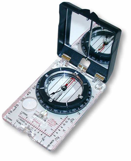
GPS and Compass
We need to know where we are located. We need to be able
to communicate that to others.
The reasons for this are obvious: so we can direct others to
a location or be directed to where
we are needed. There are systems for navigating. The one
we are going learn is simple and easy.
We will learn a system called Universal Transverse Mercator, UTM,
adopted
in 1947.
Mercator was a man who lived in the 1512-1594. He devised the
system that bears his name.
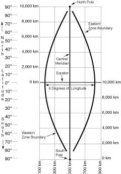
This is the name of the system we use. First they divided the
surface of the earth up into pieces
that can be managed easily on a flat surface. Starting at the
international date line, they divided
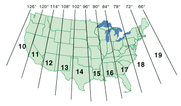
the world into 60 zones. Each zone is 6 degrees. You can see
the US mainland goes from
Zone 10 to 19 in the chart below. We here in Oregon have two
zones 10 and 11,
the 120 degree being the the line that separates the two.
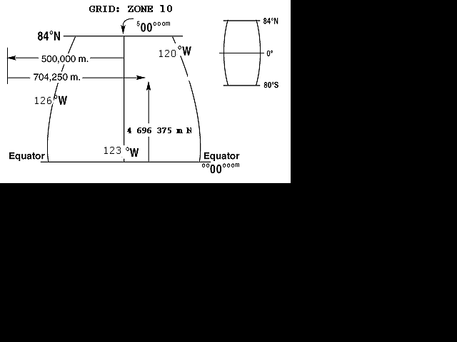
To make each zone understandable from a map perspective they placed
a line down the center
of the zone called the Meridian. This line has a
value of 500,000. There are parallel lines
placed next to the Meridian every 1000 meters. Also horizontal
spacing of lines placed every
1000 meters, creating a grid overlay. If we travel to the
west of the Meridian line, the number
of the grid line decreases by 1000 meters or a unit of one.
Traveling east of the Meridian the numbers go up.
Print the Schroeder Park Map so you will have it to refer to.
You can see that the Search and
Rescue Building in Grants Pass is located between the vertical lines
that read 471 000 and 472 000.
Actually the 471 is not labeled but 470 and 472 are. You can
see the fairgrounds and SAR
house plainly. The number 470 000 m E is an EASTING
number. If you go east or west
of the Meridian the number is still called your EASTING.
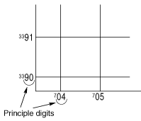
We read numbers on the grid from
the lower left corner. Reading them to the right and up.
So the line number to the left of the
Race Track at the Fairgrounds is 471 ooo m E, meaning we are
29 kilometers west of the
Meridian in Zone 10. To be in the center of the letter
"O" in the word "fairgrounds" in the
center of the track, we would say our Easting was 10 T
471 627. The 10 is for the zone.
The "T" is for the horizontal zone which we will discuss in a bit.
The 471 is for the line to our
left and the 627 is for how many meters we are to right of the 471
vertical line of the grid square.
Verbalizing this is more difficult than looking at the map. Seeing
that, we are now placed on a
vertical line, on the surface of the earth, to an accuracy of
one meter. Think about that for a
moment before we go on. That is a line, with an accuracy
to some 39 inches on the whole
of the planet's surface and we can tell some one, or know for ourselves
where
we are.
Northing Numbers
There are Horizontal bands of 8 degrees. These bands start at
80 degrees in
the southern hemisphere and stop at 84 degrees in the northern hemisphere.
These
Bands are lettered from "C" to "X" omitting letters "I and "O"
so as not to be
confused as numbers. Here in Grants Pass, Oregon we are in Band
T and our northing
number is 4, 697 000 meters north of the Equator. Starting at
the Equator for us in
the northern Hemisphere, with a value of Zero. There are parallel
lines every 1000
meters. It is as simple as that. We read our map from the lower
left corner of
the grid square. Find the numbers on the Map edge,
they tell you where you are.
See in the upper right hand corner of the map it reads Horizontal Band
T, and at
vertical line number 472. Most of your TOPO maps have the
UTM ticks on them
if not the grid lines. Most of us will deal with maps of comparatively
small
areas, the idea of zones will fade as we concentrate on the superimposed
grid
system of 1000 meter squares that have assigned values.
You can see that these grid squares are an easy way to name your location.
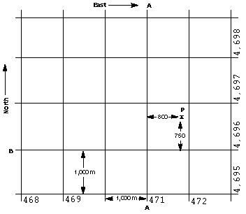
Here is a map you can see how to read from the lower left corner.
Using a grid tool or by interpolation you can see how the number reads.
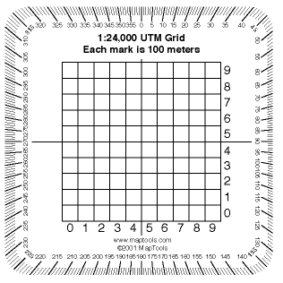
Always use a scale of 1:24 000
See the Corner Scale
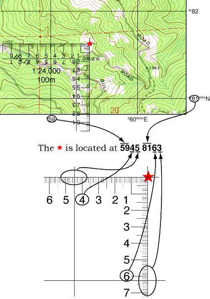
Using the Grid scale is an easy way to fix your location. With
practice you will be
able to interpolate where you are by dividing with your eye, half and
half and half
is 125 meters and so forth. Close enough to find a spring or
trail. You will want
a grid scale for SAR work.
You can find these on line. They are clear plastic and they work
great.
Now there are some things I did not tell you. How the top and
the bottom of the
world use Universal Polar Stereo graphic projections. That at
the equator each
zone of 6 degrees has a minimum and maximum Easting
value from
160,000 to
834,000. At 84 degrees a 6 degrees zone has a value of 465,000
to 515,000
Easting. That the top Northing band has 12 degrees instead
of 8 degrees.
To avoid Negative numbers locations south of the equator, the equator
was
assigned a value of 10,000,000 meters for the Southern Hemisphere.
The Equator has a value of Zero for the Northern Hemisphere.
Some northing
numbers are valid numbers both north and south of the equator, so to
avoid
confusion we have the lettered bands. Not many of us really need to
know all of this.
You now it least heard it once.
GPS
What we need to know to set up our GPS is this. Use NAD27
(that is) North
American Datum 1927 or your GPS may say NAD27 CONUS. This
puts your
GPS using the same DATUM as the TOPO map. Use Maps with a scale of
1:24, 000. Set your GPS to
Meters. Set it
to UTM, not Longitude and Latitude.
Your GPS is a radio receiver and a computer. The antenna needs
to see the sky.
If it can tell you your location in UTM, it is a good GPS.
They do not have to be
expensive. You can put yourself on the map. Let the GPS
give you your UTM.
You can find where you are.